

Phiên bản mới nhất
Phiên bản
2.4.0
2.4.0
Cập nhật
tháng 6 21, 2025
tháng 6 21, 2025
Nhà phát triển
Esri
Esri
Danh mục
Finance
Finance
Nền tảng
Android
Android
Lượt tải
0
0
Giấy phép
Free
Free
Tên gói
com.esri.earth.phone
com.esri.earth.phone
Báo cáo
Báo lỗi
Báo lỗi
Tìm hiểu thêm về ArcGIS Earth
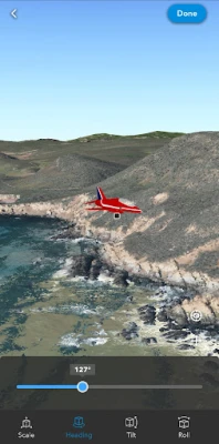
ArcGIS Earth transforms your mobile device into an interactive 3D globe for exploring geospatial data. Access authoritative organizational data, collect field data, perform measurements and exploratory analysis, and share insights with others. Whether you are online or offline, ArcGIS Earth puts the power of 3D visualization at your fingertips. Collaborate with key stakeholders to accelerate decision-making through a shared 3D perspective or digital twin of your data.
Key Features:
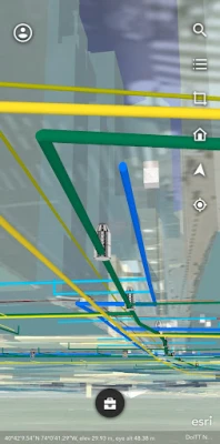
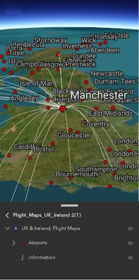
- View maps, GIS layers, and 3D content.
- Explore and visualize open 3D standards.
- Securely connect to your organizations ArcGIS Online or ArcGIS Enterprise portal.
- Search for places using world locator service or custom locator service.
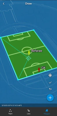
- Draw points, lines, and areas on an interactive 3D globe.
- Add notes and attach photos to drawings.
- Share drawings as KMZs or publish to ArcGIS Portal.
- Create and share tours using placemarks or geotagged photos.
- Conduct interactive 2D and 3D measurements.
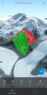
- Conduct 3D exploratory analysis like line of sight and viewshed.
- Record GPS tracks and save as a KMZ or publish to ArcGIS Portal.
- Integrate with other device apps to enable 3D visualization in field workflows.
- Position 3D data on a surface to see it in Augmented Reality.
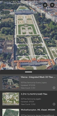
Supported Online Data Services: ArcGIS Map Service, Image Service, Feature Service, Scene Service, Web Maps, Web Scenes, 3D Tiles Hosted Service, and KML / KMZ.
Supported Offline Data: Mobile Scene Package (.mspk), KML and KMZ files (.kml and .kmz), Tile Packages (.tpk and .tpkx), Vector Tile Packages (.vtpk), Scene Layer Packages (.spk and .slpk), GeoPackage (.gpkg), 3D Tiles (.3tz), Raster Data (.img, .dt, .tif, .jp2, .ntf, .sid, .dt0…)
Note: An account is not required to browse public data on ArcGIS Online and ArcGIS Living Atlas of the World, the world's foremost collection of geospatial information.
Note: This app requires you to have a licensed ArcGIS user type to access organizational content and services.
- View maps, GIS layers, and 3D content.
- Explore and visualize open 3D standards.
- Securely connect to your organizations ArcGIS Online or ArcGIS Enterprise portal.
- Search for places using world locator service or custom locator service.
- Draw points, lines, and areas on an interactive 3D globe.
- Add notes and attach photos to drawings.
- Share drawings as KMZs or publish to ArcGIS Portal.
- Create and share tours using placemarks or geotagged photos.
- Conduct interactive 2D and 3D measurements.
- Conduct 3D exploratory analysis like line of sight and viewshed.
- Record GPS tracks and save as a KMZ or publish to ArcGIS Portal.
- Integrate with other device apps to enable 3D visualization in field workflows.
- Position 3D data on a surface to see it in Augmented Reality.
Supported Online Data Services: ArcGIS Map Service, Image Service, Feature Service, Scene Service, Web Maps, Web Scenes, 3D Tiles Hosted Service, and KML / KMZ.
Supported Offline Data: Mobile Scene Package (.mspk), KML and KMZ files (.kml and .kmz), Tile Packages (.tpk and .tpkx), Vector Tile Packages (.vtpk), Scene Layer Packages (.spk and .slpk), GeoPackage (.gpkg), 3D Tiles (.3tz), Raster Data (.img, .dt, .tif, .jp2, .ntf, .sid, .dt0…)
Note: An account is not required to browse public data on ArcGIS Online and ArcGIS Living Atlas of the World, the world's foremost collection of geospatial information.
Note: This app requires you to have a licensed ArcGIS user type to access organizational content and services.
Đánh giá ứng dụng
Thêm bình luận & đánh giá
Đánh giá người dùng
Dựa trên 0 đánh giá
Chưa có đánh giá nào.
Bình luận sẽ không được duyệt nếu là SPAM, lạm dụng, lạc đề, dùng từ ngữ thô tục, công kích cá nhân, hoặc kích động thù ghét.


Xem thêm »

Ứng dụng phổ biến

YouTubeGoogle LLC

ESET Parental ControlESET
Lịch Âm 2025 - Lịch Vạn NiênXem tử vi hàng ngày

AirDroid Parental ControlSAND STUDIO

Adobe Scan: Quét tài liệu, ảnhAdobe

VNeIDTrung tâm dữ liệu quốc gia về dân cư

Freed AudiobooksSanity Audio Apps

Rakuten Viber MessengerViber Media

MessengerMeta Platforms, Inc.

DoorDash: Food, Grocery, MoreDoorDash
Xem thêm »
Lựa chọn của biên tập viên
Adobe Scan: Quét tài liệu, ảnhAdobe

YouTube Kids 5Google LLC
YouTubeGoogle LLC

Duolingo: Học ngoại ngữDuolingo
VNeIDTrung tâm dữ liệu quốc gia về dân cư

Zalopay Thanh Toán Tích ThưởngZION JOINT STOCK COMPANY

ZaloZalo Group

FacebookMeta Platforms, Inc.
Rakuten Viber MessengerViber Media

WhatsApp BusinessWhatsApp LLC