

Phiên bản mới nhất
Cập nhật
tháng 6 16, 2025
tháng 6 16, 2025
Nhà phát triển
OsmAnd
OsmAnd
Danh mục
Travel & Local
Travel & Local
Nền tảng
Android
Android
Lượt tải
0
0
Giấy phép
115.000 ₫
115.000 ₫
Tên gói
net.osmand.srtmPlugin.paid
net.osmand.srtmPlugin.paid
Báo cáo
Báo lỗi
Báo lỗi
Tìm hiểu thêm về Contour lines plugin — OsmAnd
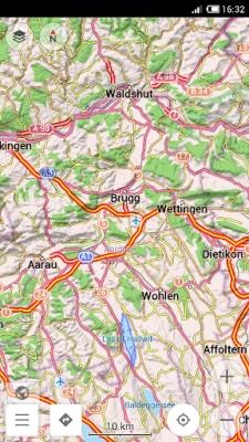
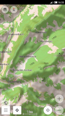
Contour lines plugin — OsmAnd is a plugin for 'Maps & Navigation — OsmAnd' app. The plugin provides extremely detailed offline topo maps that can be zoomed in and out without losing the quality. These topographic maps can also be complemented with a layer of 3D terrain representation ('hillshade'). Contour lines plugin — OsmAnd is a useful reference tool for hikers, tourists, cyclists, and any topography enthusiast.
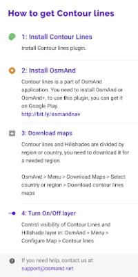
To download the contour lines and hillshade maps, please go to OsmAnd > Download maps > choose the country you need > Contour Lines/Hillshade.
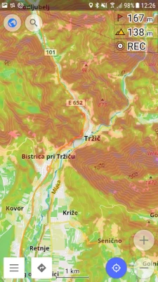
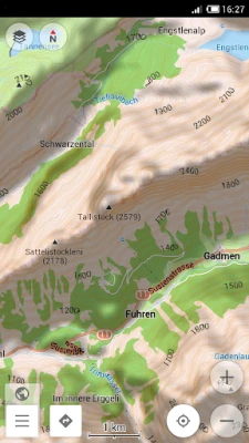
You can enable this layer of information by activating the plugin in OsmAnd > 'Plugins' and also enabling OsmAnd > Configure map > Contour Lines/Hillshade layer.
The global data (between 70 degrees north and 70 degrees south) is based on measurements by SRTM (Shuttle Radar Topography Mission) and ASTER (Advanced Spaceborne Thermal Emission and Reflection Radiometer), an imaging instrument onboard Terra, the flagship satellite of NASA's Earth Observing System. ASTER is a cooperative effort between NASA, Japan's Ministry of Economy, Trade and Industry (METI), and Japan Space Systems (J-spacesystems).
Đánh giá ứng dụng
Thêm bình luận & đánh giá
Đánh giá người dùng
Dựa trên 0 đánh giá
Chưa có đánh giá nào.
Bình luận sẽ không được duyệt nếu là SPAM, lạm dụng, lạc đề, dùng từ ngữ thô tục, công kích cá nhân, hoặc kích động thù ghét.


Xem thêm »

Ứng dụng phổ biến

ESET Parental ControlESET

AirDroid Parental ControlSAND STUDIO

Adobe Scan: Quét tài liệu, ảnhAdobe

Rakuten Viber MessengerViber Media

FacebookMeta Platforms, Inc.

Duolingo: Học ngoại ngữDuolingo

Lịch Âm 2025 - Lịch Vạn NiênXem tử vi hàng ngày

Freed AudiobooksSanity Audio Apps

Home Cafe - Mansion DesignPlaymobi Software

VNeIDTrung tâm dữ liệu quốc gia về dân cư
Xem thêm »
Lựa chọn của biên tập viên
Adobe Scan: Quét tài liệu, ảnhAdobe

YouTube Kids 5Google LLC

YouTubeGoogle LLC
Duolingo: Học ngoại ngữDuolingo
VNeIDTrung tâm dữ liệu quốc gia về dân cư

Zalopay Thanh Toán Tích ThưởngZION JOINT STOCK COMPANY

ZaloZalo Group
FacebookMeta Platforms, Inc.
Rakuten Viber MessengerViber Media

WhatsApp BusinessWhatsApp LLC