

Phiên bản mới nhất
Cập nhật
tháng 7 01, 2025
tháng 7 01, 2025
Nhà phát triển
Geolives Belgium S.R.L.
Geolives Belgium S.R.L.
Danh mục
Travel & Local
Travel & Local
Nền tảng
Android
Android
Lượt tải
0
0
Giấy phép
Free
Free
Tên gói
com.geolives
com.geolives
Báo cáo
Báo lỗi
Báo lỗi
Tìm hiểu thêm về SityTrail hiking trail GPS
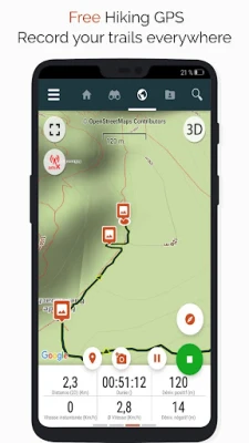
Go and discover all the paths around the world
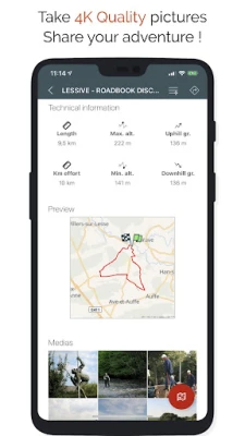
• Record your trails while taking HD and geo-tagged pictures of your adventures.
• Travelled distance, Km-effort, average speed, calories burned, etc.
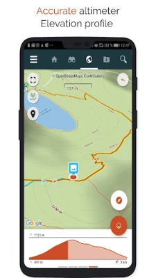
• Accurate altimeter, height differences computing and elevation profile displaying your current location.
• Alarm when you go off the path of the trail being followed. No more need to backtrack!
• Automatic triggering of points of interest with text-to-speech.
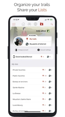
• Create a free account and all your data will be available everywhere on every device.
• Easy creation of trails and points of interest from our website.
• With our online editor, create your own trails using a Web browser on your PC/Mac and then access them directly from your smartphone to experience them on the ground.
• Sort and classify your trails and points of interest in your own lists.
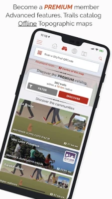
Go further and become a PREMIUM user!
• Download world topographic maps for offline use.
• Discover GR hiking paths, European hiking routes, Santiago de Compostela routes for pilgrims, etc.
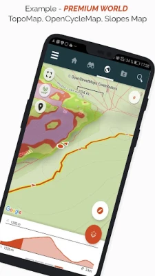
• Add topographic maps of your choice, from IGN France, IGN / NGI Belgium, IGN Spain, swisstopo, Austria, USA (USGS topographic mapping), Canada (Toporama).
• You can also discover all cycling networks: Greenway network in France, Ravel in Belgium, European cycling routes, knot points networks in Flanders and the Netherlands.
• And in winter, discover all the ski slopes with their names.
• Access the public catalogue of trails from SityTrail members and communities.
• Advanced tracking and guiding features with calculation of the remaining distance and time and vocal instructions at intersections.
• Go further and transform your favourite trails into real multimedia guides with text, photos, video links, and share them with the SityTrail community.
• Create your own hiker communities and manage your members and newsfeeds.
• Create trails with our advanced features for trail editing via our website.
• Print trails in PDF format with QR codes. (A4, A3).
• Access geotagged Wikipedia articles from our SityTrip module.
Record a trail on your Wear OS watch
You can record a trail on your Wear OS watch in standalone mode (not connected to an Android smartphone) or in paired mode (connected to an Android smartphone).
The application also allows logging in to your existing SityTrail account (from the screen which is the most on the left) when the watch is used in standalone mode.
Important Information
• Some features need an internet connection.
• The prolonged use of GPS can reduce battery levels.
• Travelled distance, Km-effort, average speed, calories burned, etc.
• Accurate altimeter, height differences computing and elevation profile displaying your current location.
• Alarm when you go off the path of the trail being followed. No more need to backtrack!
• Automatic triggering of points of interest with text-to-speech.
• Create a free account and all your data will be available everywhere on every device.
• Easy creation of trails and points of interest from our website.
• With our online editor, create your own trails using a Web browser on your PC/Mac and then access them directly from your smartphone to experience them on the ground.
• Sort and classify your trails and points of interest in your own lists.
Go further and become a PREMIUM user!
• Download world topographic maps for offline use.
• Discover GR hiking paths, European hiking routes, Santiago de Compostela routes for pilgrims, etc.
• Add topographic maps of your choice, from IGN France, IGN / NGI Belgium, IGN Spain, swisstopo, Austria, USA (USGS topographic mapping), Canada (Toporama).
• You can also discover all cycling networks: Greenway network in France, Ravel in Belgium, European cycling routes, knot points networks in Flanders and the Netherlands.
• And in winter, discover all the ski slopes with their names.
• Access the public catalogue of trails from SityTrail members and communities.
• Advanced tracking and guiding features with calculation of the remaining distance and time and vocal instructions at intersections.
• Go further and transform your favourite trails into real multimedia guides with text, photos, video links, and share them with the SityTrail community.
• Create your own hiker communities and manage your members and newsfeeds.
• Create trails with our advanced features for trail editing via our website.
• Print trails in PDF format with QR codes. (A4, A3).
• Access geotagged Wikipedia articles from our SityTrip module.
Record a trail on your Wear OS watch
You can record a trail on your Wear OS watch in standalone mode (not connected to an Android smartphone) or in paired mode (connected to an Android smartphone).
The application also allows logging in to your existing SityTrail account (from the screen which is the most on the left) when the watch is used in standalone mode.
Important Information
• Some features need an internet connection.
• The prolonged use of GPS can reduce battery levels.
Đánh giá ứng dụng
Thêm bình luận & đánh giá
Đánh giá người dùng
Dựa trên 0 đánh giá
Chưa có đánh giá nào.
Bình luận sẽ không được duyệt nếu là SPAM, lạm dụng, lạc đề, dùng từ ngữ thô tục, công kích cá nhân, hoặc kích động thù ghét.


Xem thêm »

Ứng dụng phổ biến

Zalopay Thanh Toán Tích ThưởngZION JOINT STOCK COMPANY

FacebookMeta Platforms, Inc.

YouTubeGoogle LLC

Adobe Scan: Quét tài liệu, ảnhAdobe

ZaloZalo Group

Rakuten Viber MessengerViber Media

VNeIDTrung tâm dữ liệu quốc gia về dân cư

Duolingo: Học ngoại ngữDuolingo

MessengerMeta Platforms, Inc.

GPS định vị & theo dõi vị tríANKO Solutions LLC
Xem thêm »
Lựa chọn của biên tập viên
Adobe Scan: Quét tài liệu, ảnhAdobe

YouTube Kids 5Google LLC
YouTubeGoogle LLC
Duolingo: Học ngoại ngữDuolingo
VNeIDTrung tâm dữ liệu quốc gia về dân cư
Zalopay Thanh Toán Tích ThưởngZION JOINT STOCK COMPANY
ZaloZalo Group
FacebookMeta Platforms, Inc.
Rakuten Viber MessengerViber Media

WhatsApp BusinessWhatsApp LLC